


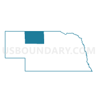
Kennedy Precinct, Cherry County, Nebraska
About
Outline

Summary
| Unique Area Identifier | 612590 |
| Name | Kennedy Precinct |
| County | Cherry County |
| State | Nebraska |
| Area (square miles) | 239.74 |
| Land Area (square miles) | 236.21 |
| Water Area (square miles) | 3.53 |
| % of Land Area | 98.53 |
| % of Water Area | 1.47 |
| Latitude of the Internal Point | 42.52230380 |
| Longtitude of the Internal Point | -101.03845940 |
Maps


Graphs
Select a template below for downloading or customizing gragh for Kennedy Precinct, Cherry County, Nebraska


Neighbors
Neighoring Voting District (by Name) Neighboring Voting District on the Map
- Barley Precinct, Cherry County, NE
- Cleveland Precinct, Cherry County, NE
- Gillaspie Precinct, Cherry County, NE
- Loup Precinct, Cherry County, NE
- Wells Precinct, Cherry County, NE
Top 10 Neighboring County Subdivision (by Population) Neighboring County Subdivision on the Map
- Loup precinct, Cherry County, NE (233)
- Wells precinct, Cherry County, NE (129)
- Cleveland precinct, Cherry County, NE (108)
- Barley precinct, Cherry County, NE (89)
- Kennedy precinct, Cherry County, NE (57)
- Gillaspie precinct, Cherry County, NE (43)